 Looking west down Northwest First Street... in prairie towns, the sky is still the biggest thing around.
 South on Highland Avenue, the water in Silver Creek is about two feet from the bottom of the bridge.
 I take it all this rain has been good for corn... at least the corn on the high ground. This corn on the way to the state park looks like "knee high by the Fourth" won't be a problem. But like the water elsewhere, this corn is creeping into the ditch.
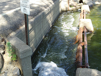
The Lake Herman spillway that sends water to Madison (and Lake Madison, and Lake Brant, and ultimately the Big Sioux River) is topped out.
 Dick Simpson's dock isn't fit for sitting... unless you're wearing your swim trunks. His dock panels wait on shore for drier fishing weather.
 GF&P is keeping its dock at the public boat ramp just barely above water. Last year around this time, nine or ten of those big concrete slabs forming the boat ramp lay above the water line. This year, only four slabs are dry. Another gauge: I went swimming yesterday in front of my place. The shore where I could just get my toes wet last June is now under two and a half feet of water.
 We refer to the bump in the shore southeast of the boat ramp as "The Point" (akin to "The River," "The Hills," and "The Cities"). I think some maps call it "Stony Point." From the boatramp, one usually sees a long line of rip-rap stones where fishermen can sit in the shade. Those stones are all submerged.


 This blog printed on 100% recycled electrons.


Thanks for the pics of our beautiful city and park!!
ReplyDelete